Windows 8 Support

  • Subscribe to our RSS feed.
  • Twitter
  • StumbleUpon
  • Reddit
  • Facebook
  • Digg
Showing posts with label AutoCAD Civil 3D. Show all posts

Monday, 14 October 2013

BIM Workflow for Roads and Highways

Posted on 10:00 by Unknown
This year, Ideate is offering a new class based on the BIM for Road and Highway design to go along with Autodesk’s new BIM Specialist: Roads and Highways certification. 

Although the concept of BIM or Building Information Modeling has been around for years, its integration into the world of Road and Highway design has been relatively slow when compared to that of Building design. The 2014 Autodesk Infrastructure Design Suite provides users with core products for use in BIM modeling for Roads and Highways. In this article, we’ll talk about the products involved, and some the roles they play in the BIM Workflow process.

When looking at the list of products in the Infrastructure Design suite – Ultimate version, we’ll find applications for many stages of the project lifecycle. For the purpose of our blog, we’ll break this down into three main areas.

Stage 1: Planning and Preliminary Design
Stage 2: Detailed Design and Documentation
Stage 3: Construction Simulation/Management

For Stage 1, Autodesk InfraWorks is available to combine both existing and proposed data sources and create a virtual 3D model of a planned development. Autodesk InfraWorks is compatible with GIS, AutoCAD, Civil 3D, Revit, Point Cloud and other data types and also includes tools for creating proposed features and cloud-based profile optimization for road design. 

Once models are created, Autodesk InfraWorks also includes tools for creating storyboards, virtual fly-throughs, and scenarios for communicating design concepts. Finally, Autodesk InfraWorks models can easily be exported and imported into Autodesk AutoCAD Civil 3D for continuing on to the next stage of the design process.

The Autodesk AutoCAD Civil 3D modeling tools provide civil engineers with the ability to add large amounts of information to the models for use in the BIM process. Built-in analysis tools like Storm and Sanitary Analysis and Hydraflow, along with  plan production tools to automatically cut Plan and Profile and Section Sheets make AutoCAD Civil 3D an excellent program to use for Stage 2 of our workflow. Additional tools for Quantity Take-offs, earthwork, and material volume calculations also provide the necessary data for construction cost estimates based on the information contained in our models.

Once designs are finalized, we can move on to Stage 3 of our BIM Workflow.  Model components can be exported back to Autodesk InfraWorks for high quality visualizations of the final design, and imported into Navisworks Manage for construction management and simulation. Both applications are also compatible with files from Autodesk Revit as well as other software packages, giving us the ability to create realistic composite models using data received from all parties involved in a project.

Within Navisworks Manage, the Timeliner tool can be used for creating 4D and 5D construction simulations by linking model components to timelines created in project scheduling software like Microsoft Project or Primavera.

Along with the Timeliner, Navisworks Manage also includes Clash Detection for detecting clearance violations and hard clashes between model components.  Simulated construction sequencing and virtual clash detection help save time and money through early detection of issues that could lead to costly redesigns and change orders if found during construction.

So there you have it, Autodesk InfraWorks for preliminary planning stage design, Autodesk AutoCAD Civil 3D for detailed design and construction documentation, then back to Autodesk InfraWorks or into Autodesk Navisworks Manage for advanced visualizations, construction simulation, clash detection and construction management. A BIM Workflow for Road and Highway design using applications included in the 2014 Autodesk Infrastructure Design Suites.

Interested in finding out more? Visit our website for the next open enrollment class on BIM Workflow for Roads & Highways and to find out more about Autodesk’s BIM Specialist: Roads & Highways certification.


Matt Miyamoto, P.E.
Ideate AEC Application Specialist

Matt is an Application Specialist at Ideate, Inc. and is a licensed Civil Engineer with over 10 years of industry experience. He has successfully completed the BIM Specialist: Roads & Highways certification and helps to provide training, consulting and technical support services for our customers at Ideate, Inc. @MattM_PE

Get it. Know it. Use it.
Read More
Posted in AutoCAD, AutoCAD Civil 3D, Autodesk Revit, BIM, gis, highways, Ideate, Infrastructure Design Suite, InfraWorks, matt miyamoto, point cloud, quantity takeoff, roads, Storm and Sanitary Analysis, workflows | No comments

Thursday, 10 October 2013

Ideate, Inc. Publishes a First – a Civil 3D Virtualization Study in Success

Posted on 10:00 by Unknown
SAN FRANCISCO, California – 10/10/2013 - Autodesk Gold Value Added Reseller Ideate, Inc., a solutions provider offering quality software, training, support and custom consulting services to the Architecture, Engineering and Construction (AEC) industry, today announced the publication of its first Virtualization-focused Study in Success, “Ideate Consulting and IMSCAD Lead ESA to Autodesk Design Solution Virtualization Mastery.”

Ideate customer Environmental Science Associates (ESA), a leading environmental science and planning firm with offices in the Western and Southeastern United States, faced challenges when the firm needed to seamlessly integrate IT hardware and its office and accounting software with graphics-intense Autodesk design technology software. Virtualization looked promising, provided it could be achieved within the firm’s desired parameters of a reliable, cost effective, and functional solution.

ESA enlisted Ideate Consulting and its strategic ally, UK-based IMSCAD, and as John Lessard, Director of Information Technology, ESA, said, “We spent several hours at Ideate. The comparison to anything we had experienced to date was night and day. We determined that the concept of running AutoCAD Civil 3D in a Citrix environment was not only possible. Virtualization, it turned out, was very doable.”

The first-of-its-kind Study in Success reveals how these expert allies partnered in scoping, installing, and configuring the components, then implementing a successful desktop virtualization project that is working for ESA with Autodesk design software, and specifically with AutoCAD Civil 3D.

Bob Palioca, President, Ideate Inc., says, “Being able to use any hardware from anywhere is facilitating fast-paced collaboration for ESA. The firm is streamlining software deployment and upgrade procedures, all while lowering its costs. Our goal is always to have our customers be overwhelmingly delighted with the solutions we provide, and we could not be more pleased.”

Ideate has published “Ideate Consulting and IMSCAD Lead ESA to Autodesk Design Solution Virtualization Mastery,” online. Download the Study in Success at ideateinc.com/ideas/case

About Ideate, Inc.
Ideate, Inc. is a leading Autodesk Authorized Developer with 25+ years’ experience in software development and specific focus on Building Information Modeling (BIM) and is a leading Autodesk solutions provider offering quality software, training, support and custom consulting services to the AEC industry since 1992. Headquartered in San Francisco, California and operating five Autodesk Authorized Training Centers (ATCs) in the northwestern U.S., Ideate is recognized as an Autodesk Gold Partner for Architecture, Engineering and Construction, one of Autodesk’s highest levels of authorization.

Autodesk, AutoCAD, ATC and Civil 3D are registered trademarks or trademarks of Autodesk, Inc., and/or its subsidiaries and/or affiliates in the USA and/or other countries.

Citrix is a trademark of Citrix Systems, Inc. and/or one or more of its subsidiaries, and may be registered in the United States Patent and Trademark Office and in other countries.


# # #
Read More
Posted in AutoCAD Civil 3D, Autodesk Consulting Services Partner, Bob Palioca, Citrix, Environmental Science Associates, ESA, Ideate, Ideate Consulting, IMSCAD, Virtualization | No comments

Wednesday, 3 July 2013

AutoCAD Command Line Below the Ribbon…

Posted on 10:00 by Unknown
As an instructor for AutoCAD and Civil 3D classes here at Ideate, I tend to reposition some of the components of my AutoCAD application on screen to make it easier for students to see them.  One of the changes I make most commonly is moving the Command Line from its default location at the bottom of the screen to the top of the screen below the Ribbon.  Unfortunately, AutoCAD does not seem to like this particular spot.

For any of you who have customized your workspace and also chose this location, you may notice that when AutoCAD starts up, it repositions the Command Line and Ribbon so they are side by side rather than stacked with the Ribbon above as you saved it with the Workspace.

 
Here’s what was Saved with the Workspace: Command Line below the Ribbon

When AutoCAD is launched from scratch, the side by side version of the Ribbon and Command Line appears instead.


Default Launch: Command Line on the side of the Ribbon

Unfortunately, this is an issue that has been occurring with the past releases of AutoCAD, and continues with the 2014 version. Luckily, there’s a relatively quick and easy workaround that can move the Command Line back to where it should be.

After a few years of manually moving the Command Line back to below the Ribbon (and finding out that it prefers to be stacked above rather than below), I noticed that switching to a different workspace, then switching it back to my custom workspace also did the trick. If done manually, this takes a few seconds as you will need to wait for the alternate workspace to load, and then switch back. If a simple script is used, the process is done automatically and occurs much faster.

The script is very basic (only seven lines total) and can be written in any basic text editor application. All it does is use the WORKSPACE command to set the default Civil 3D workspace current, then use the same command again to switch back to the custom workspace, in this case named TECH SUPPORT. A simple “drag and drop” process with the script file runs it automatically in AutoCAD, and you won’t have to wait for the alternate workspace to load as you would if done manually from the Workspace dropdown.

Here’s a screenshot of the content of the script (.SCR) file.


And here’s a recording of the script in action.


If you’ve been trying to customize the Command Line to a spot below the Ribbon and have run into the same problem, here’s a quick and easy script-based workaround to use.


Matt Miyamoto, P.E.
Ideate AEC Application Specialist

Matt is a licensed Civil Engineer in the state of Hawaii. Matt obtained a BS in Mechanical Engineering from the University of Hawaii at Manoa, and has 7 years of private sector design experience which he applies in his role as an application specialist with Ideate, Inc. His project experience includes residential and commercial site development, private and public sewer, water and drainage systems, harbors improvements, and roadway improvements. While in Hawaii, Matt was involved in multidisciplinary projects for City and County agencies, State Departments, the Army COE and private developers. @MattM_PE

Get it. Know it. Use it.
Read More
Posted in AutoCAD, AutoCAD Civil 3D, Below Ribbon, Command Line, Commandline, Ideate, matt miyamoto, Workspace | No comments

Tuesday, 2 July 2013

Important Information: Action may be required Change in Autodesk Infrastructure Design Suites Migration Policy

Posted on 11:01 by Unknown
Autodesk recently sent subscription customers information regarding the automatic AutoCAD® Civil 3D® and AutoCAD® Map 3D upgrade offer to Autodesk® Infrastructure Design Suite 2014 Premium and Standard.  Ideate wants to make you aware of a change to the program. Based on your feedback Autodesk has decided to withdraw the offer to upgrade you automatically to Infrastructure Design Suite Premium or Standard and instead provide you with the option of choosing to upgrade. Autodesk still believes the Infrastructure Design Suite is the right solution for you but are changing the automatic upgrade offer in order to allow you the freedom to choose and make the best decision for your business.

You Decide

If you already opted out on the previous communication Autodesk sent you, no further action is required.

If you are an AutoCAD Civil 3D 2013 customer on Autodesk Subscription Autodesk is offering you the opportunity to upgrade to Autodesk Infrastructure Design Suite 2014 Premium at no cost between now and July 15th 2013. This is a change from the previously communicated program and your access to Autodesk Infrastructure Design Suite will no longer be available unless you opt in by July 15th 2013. Autodesk Infrastructure Design Suite Premium is a comprehensive BIM for Infrastructure software solution that provides intelligent model-based tools to help you gain more accurate and actionable insight throughout the lifecycle of your infrastructure project with access to desktop and cloud solutions.

If you are an AutoCAD Map 3D 2013 customer on Autodesk Subscription Autodesk is offering you the opportunity to upgrade to Autodesk Infrastructure Design Suite 2014 Standard at no cost between now and July 15th 2013. This is a change from the previously communicated program and your access to Autodesk Infrastructure Design Suite will no longer be available unless you opt in by July 15th 2013. Autodesk Infrastructure Design Suite Standard offers foundational planning, design and coordination capabilities both on the desktop and in the cloud.

If you do not take action by July 15th 2013, you will automatically be opted out and will receive the 2014 version of AutoCAD Civil 3D or AutoCAD Map 3D and current subscription entitlements for which you are eligible.

Learn More

Make sure to review email communications sent by Autodesk to Subscription customers for instructions and information including subscription renewal price changes associated with this migration. For additional information, please visit www.autodesk.com/idsmigration_help.

If you would like to learn more about Autodesk Infrastructure Design Suite visit our website at www.ideateinc.com.

Ideate understands these migrations represent changes that affect budgeting and planning for software solution purchases. Our sales and support teams stand ready to answer any questions about the Autodesk changes and how they may affect you and your firm.

Phone: 888.662.7238
Email: sales@ideateinc.com
Read More
Posted in AutoCAD, AutoCAD Civil 3D, Autodesk, Autodesk Subscription, Ideate, Infrastructure Design Suite, Map 3D | No comments

Tuesday, 23 April 2013

Classroom Training – Open Classes

Posted on 13:00 by Unknown
Know It. Ideate Training.

Position yourself to land dream projects. Tap the full potential of your software solutions. Increase your facility, fluidity and capability to maximize the value of your precision software tools.

Here are a few of the training opportunities Ideate has to offer in the coming weeks:
4.24-26::Portland
Civil 3D Fundamentals
5.1-3::
San Jose

AutoCAD Fundamentals
5.6
-8::Portland

Revit Architecture Fundamentals
5.6-8::Sacramento
Revit Architecture Fundamentals
Know your software. Sign up now!
Read More
Posted in AIA CEU, AIA LU, ATC, Authorized Training Center, AutoCAD, AutoCAD Civil 3D, autodesk revit architecture, gaurav bagga, Ideate, Ideate Inc., matt miyamoto, Revit, Revit Training, sash kazeminejad, shruti harve | No comments

Tuesday, 16 April 2013

Classroom Training – Open Classes

Posted on 13:00 by Unknown
Know It. Ideate Training.

Position yourself to land dream projects. Tap the full potential of your software solutions. Increase your facility, fluidity and capability to maximize the value of your precision software tools.

Here are a few of the training opportunities Ideate has to offer in the coming weeks:
4.24-26::Portland
Civil 3D Fundamentals
5.1-3::
San Jose

AutoCAD Fundamentals
5.6
-8::Portland

Revit Architecture Fundamentals
Know your software. Sign up now!
Read More
Posted in AIA CEU, AIA LU, ATC, Authorized Training Center, AutoCAD, AutoCAD Civil 3D, autodesk revit architecture, gaurav bagga, Ideate, Ideate Inc., matt miyamoto, Revit, Revit Training, sash kazeminejad | No comments

Thursday, 11 April 2013

eLearning – Upcoming Classes

Posted on 13:00 by Unknown
Join the Ideate Tech Experts for eLearning – live online classes that provide your entire organization with easy access to premium education. 

Upcoming classes include: 
4.15.13::
Civil 101: Civil 3D for Beginners
4.16.13::

Revit 201: Site Tools
4.23.13::

Ideate 101: Network License Manager
Each class is designed to give you specific, improved results in a particular topic. You can interact with the instructor right from your own office, while eliminating travel time. Because the class schedule rotates, you can easily select your topics of interest and choose the day which best meets your schedule.

Click here for class descriptions, times and registration link. Questions? Contact education@ideateinc.com

Get It. Know It. Use It.
Read More
Posted in AIA CEU, AIA LU, AutoCAD Civil 3D, Autodesk License Manager, Derek Wielkopolski, eLearning, gaurav bagga, Ideate, Ideate Inc., Revit, Revit Training, RonPalmaAEC | No comments

Thursday, 4 April 2013

eLearning – Upcoming Classes

Posted on 13:00 by Unknown
Join the Ideate Tech Experts for eLearning – live online classes that provide your entire organization with easy access to premium education. 

Upcoming classes include: 
4.9.13::Revit 201:
Revit for Interior Designers
4.15.13::
Civil 101:
Civil 3D for Beginners
4.16.13::
Revit 201:
Site Tools
Each class is designed to give you specific, improved results in a particular topic. You can interact with the instructor right from your own office, while eliminating travel time. Because the class schedule rotates, you can easily select your topics of interest and choose the day which best meets your schedule.

Click here for class descriptions, times and registration link. Questions? Contact education@ideateinc.com

Get It. Know It. Use It.
Read More
Posted in AIA CEU, AIA LU, AutoCAD Civil 3D, eLearning, gaurav bagga, Ideate, Ideate Inc., Revit, Revit Training, RonPalmaAEC, shruti harve | No comments

Thursday, 28 March 2013

eLearning – Upcoming Classes

Posted on 13:00 by Unknown
Join the Ideate Tech Experts for eLearning – live online classes that provide your entire organization with easy access to premium education. 

Upcoming classes include: 
4.2.13::Navisworks 201:
Worksharing Best Practices
4.9.13::Revit 201:
Revit for Interior Designers
4.15.13::Civil 101:
Civil 3D for Beginners
Each class is designed to give you specific, improved results in a particular topic. You can interact with the instructor right from your own office, while eliminating travel time. Because the class schedule rotates, you can easily select your topics of interest and choose the day which best meets your schedule.

Click here for class descriptions, times and registration link. Questions? Contact education@ideateinc.com

Get It. Know It. Use It.
Read More
Posted in AIA CEU, AIA LU, AutoCAD Civil 3D, Autodesk Navisworks, eLearning, gaurav bagga, Ideate, Ideate Inc., Jim Cowan, Revit, Revit Training, shruti harve | No comments

Thursday, 21 March 2013

eLearning – Upcoming Classes

Posted on 13:00 by Unknown
Join the Ideate Tech Experts for eLearning – live online classes that provide your entire organization with easy access to premium education. 

Upcoming classes include: 
3.26.13::Revit 201:
Worksharing Best Practices
4.15.13::Civil 101:
Civil 3D for Beginners
Each class is designed to give you specific, improved results in a particular topic. You can interact with the instructor right from your own office, while eliminating travel time. Because the class schedule rotates, you can easily select your topics of interest and choose the day which best meets your schedule.

Click here for class descriptions, times and registration link. Questions? Contact education@ideateinc.com

Get It. Know It. Use It.
Read More
Posted in AIA CEU, AIA LU, AutoCAD Civil 3D, bill johnson, eLearning, gaurav bagga, Revit, Revit Architecture, Revit Training | No comments

Thursday, 14 March 2013

eLearning – Upcoming Classes

Posted on 10:00 by Unknown
Join the Ideate Tech Experts for eLearning – live online classes that provide your entire organization with easy access to premium education. 

Upcoming classes include: 
3.18.13::Ideate Software 101:
Revit Project Management with Ideate BIMLink
3.26.13::Revit 201:
Worksharing Best Practices
4.15.13::Civil 101:
Civil 3D for Beginners
Each class is designed to give you specific, improved results in a particular topic. You can interact with the instructor right from your own office, while eliminating travel time. Because the class schedule rotates, you can easily select your topics of interest and choose the day which best meets your schedule.

Click here for class descriptions, times and registration link. Questions? Contact education@ideateinc.com

Get It. Know It. Use It.
Read More
Posted in AIA CEU, AIA LU, AutoCAD Civil 3D, bill johnson, eLearning, Excel to Revit, gaurav bagga, Ideate, Ideate BIMLink for Revit 2013, Revit, Revit Architecture, Revit to Excel, Revit tool, Revit Training, shruti harve | No comments

Monday, 25 February 2013

Autodesk Infrastructure Modeler for Interoperability – .IMX and .FBX Files

Posted on 10:00 by Unknown
Here at Ideate, Inc., we often receive requests from customers for information on how they can take advantage of their current Autodesk Suite of products to make modeling and visualization easier. Is there anything that can incorporate GIS data for existing features? Is there a product that can use model data that we already have in Civil 3D or Revit to create rendered animations? 

The answer to those questions is: Autodesk Infrastructure Modeler. And the best part is, if you’re on subscription with the right Autodesk Suite of products, you can have it for free. Autodesk Building Design Suite Ultimate, and Autodesk Infrastructure Design Suite Premium and Ultimate editions include AIM. 

Introduced in 2011, Autodesk Infrastructure Modeler has the ability to quickly and easily generate a 3D model from existing GIS and other data sources. In most cases, GIS data in the form of SDF, SHP along with Raster Images are used to generate the base of the AIM Model. For proposed features like buildings, roads, and sitework, the 2013 releases of Revit Architecture and Civil 3D include built-in exporting tools that generate AIM compatible files. These files come in .FBX and .IMX formats and can be imported directly into an AIM project. 

In Revit Architecture, the Export command under the Application Icon (Purple “R” in the upper left corner) includes the FBX option that allows users to export the 3D View to a FBX file. In the FBX file, both the building model and the toposurface will be included. 


In Civil 3D, the Output tab → Export panel of the Ribbon includes an Export IMX icon for exporting Civil 3D objects to AIM compatible format. The IMX file contains data from Civil 3D objects in the drawing and can be used to re-create those objects in AIM. Alignments can be easily converted and stylized to display proposed roads, and surfaces can be exported and combined to display existing and developed conditions.


As of October 2012, an enhanced version of AIM was posted and available for download to Subscription customers. Autodesk Infrastructure Modeler 2013 R2 can be found on the main Subscription Benefits page after logging in to Subscription Center. AIM R2 has been enhanced with new tools for communicating and presenting proposed designs. 

NOTE: If you’re considering AIM R2, please note that the existing version of AIM needs to be uninstalled from your computer before you install AIM R2. 

Also included in the AIM R2 package is an iPad® compatible version called Autodesk 360 Infrastructure Modeler for Mobile and a web-based version called Autodesk Infrastructure Modeler for Web that works on 32-bit Internet Explorer. Here’s the Autodesk Infrastructure Modeler 2013 R2 info per Subscription Center: 

Autodesk Infrastructure Modeler 2013 R2
Release Date: 2012-10-04 


Autodesk® Infrastructure Modeler 2013 R2 software delivers several enhancements to our Autodesk® Infrastructure Modeler 2013 desktop software and our Autodesk® 360 Infrastructure Modeler cloud service. With the extension, Autodesk® Subscription customers will gain new tools designed to help better communicate their designs and produce high quality, low-touch design presentations in addition to new publishing options. 

  • Storytelling Tools Enables users to better convey the details of their designs to non-technical audiences with the ability to create camera paths, fly-through animations, and videos that include titles, captions, points of interest and storyboards without needing video editing software. 
  • Rendering More Realistic Models Helps users produce higher quality renderings with new photorealism tools like progressive ray trace, more realistic sun/sky models, and high and low definition range output. 
  • Open Standards Support – Enables user to access CityGML, the standard many municipal bureaus in Europe use to store city data. CityGML data may contain a whole city’s structure (including detailed 3D models), roads, pipes, and textures in different levels of detail. The inclusion of CityGML can greatly improve our user’s ability to incorporate detailed data into their designs that was previously unavailable. 
  • Autodesk 360 Infrastructure Modeler for Mobile Now, infrastructure professionals can share their models as well as specific scenarios in a more secure cloud environment - via Autodesk® BIM 360™ cloud-based services- with public stakeholders who want the ease and convenience of using an iPad® mobile digital device. 
  • Autodesk 360 Infrastructure Modeler for Web The new Web application enables interested parties who are not Autodesk Infrastructure Modeler 2013 users to view models and specific scenarios via a link using their Web browser, giving broader access to project proposals and more. 
We’ve also posted a short fly-through video or a proposed road made with the new Storytelling tools to our YouTube page. The existing ground model and roads were imported via IMX file from Civil 3D and the road used in the fly-through (including light posts, median and intersections) was created directly in AIM R2. The process of setting up the model to producing the recording took about 30 minutes. The quality of this video clip has been lowered so we could post it on the web (down to 3 MB). The original video produced by AIM R2 is just under 3 GB. 


Matt Miyamoto, P.E.
Ideate AEC Application Specialist

Matt is a licensed Civil Engineer in the state of Hawaii. Matt obtained a BS in Mechanical Engineering from the University of Hawaii at Manoa, and has 7 years of private sector design experience which he applies in his role as an application specialist with Ideate, Inc. His project experience includes residential and commercial site development, private and public sewer, water and drainage systems, harbors improvements, and roadway improvements. While in Hawaii, Matt was involved in multidisciplinary projects for City and County agencies, State Departments, the Army COE and private developers. @MattM_PE

Get it. Know it. Use it.
Read More
Posted in AIM, AutoCAD Civil 3D, autodesk infrastructure modeler, autodesk revit architecture 2013, Civil 3D, Ideate, Ideate Inc., Infrastructure Design Suite, matt miyamoto | No comments

Wednesday, 23 January 2013

Import Sketchup Model into Autodesk Infrastructure Modeler

Posted on 10:00 by Unknown
At Ideate, we are asked about the value of purchasing the Infrastructure Design Suite. Included in Infrastructure Design Suite Premium and Ultimate is Autodesk Infrastructure Modeler; a great program for quickly visualizing your design in context for meetings with stakeholders and/or clients.
 

Problem – you are using Infrastructure Modeler to present your next urban development project proposal. And to make it more realistic and compelling you want to insert a 3D model of the nearby landmark giving the project stakeholders a visual perspective. You have seen 3D models of buildings in Google Earth but this is Infrastructure Modeler. Not Google Earth!
 

The 3D buildings you see in Google Earth are sketchup models. But can you import these 3D models in Infrastructure Modeler?


Is it possible to import any sketchup model into Infrastructure Modeler? The answer is Yes. Here’s how!
 

Before I raise your hopes – I am not aware of any direct way to achieve this so we will have to take a detour via Civil 3D.
 

So the process is to:
1. Import the model first into Civil 3D by using the Sketchup Import plug-in. This plug-in can be downloaded and installed from Autodesk Exchange which is found in the Infocenter on the top right as shown below.
2. Then export this model to an FBX file
3. And finally import and configure it in Infrastructure Modeler. Configuring includes move, scale, rotate as necessary to georeference.
You can possibly insert the sketchup model in Civil 3D project drawing that contains the georeferenced image and terrain and move, scale and rotate the model to georeference it here in Civil 3D.
 
Import the Model in Civil 3D
From within Civil 3D, Plug-ins tab > Sketchup Import panel > click on Get 3D Model


From Sketchup Import – Get 3D Model window, click on Download Model to download and insert the model in Civil 3D. Depending upon what’s available you will be given options – I got the 9MB model.


Here is the 3D model of Golden Gate Bridge in Civil 3D.


Export the Model to FBX
Go To Application Menu > Export and save the file as FBX format.


In the FBX Export Options dialog box, choose what you want to export appropriately – I exported everything visible – the drawing had only one model.


Import the Model in Infrastructure Modeler
From within Infrastructure Modeler, click on Data Source in the Home tab to open the Data Source palette. Click 3D Model as shown below and then pick the above FBX file. I had already imported the surface and image from Civil 3D 2012 using LandXML and Raster data sources, respectively.


Once the model is imported you need to configure it.
 

In the Data Source palette, double click on the row corresponding to the FBX file you just imported.
 

In the Data Source configuration dialog box,
Assign it a type depending upon the data, I chose Buildings, could have chosen City Furniture as well.
Assign a coordinate system to the data source (on the top), in this case I used XY-FT because the data does not have any coordinate system. Then there is a coordinate system for where the data will get placed in the model - I assigned the appropriate California State Plane coordinate system. I also had to scale the model down 12 times to convert meters to feet. You can see the scale factor of 0.083 for X, Y, Z. 
Click on Interactive Placing… and then double click in the model area to place the sketchup model in the project. Remember, it’s a double click. 
You may have to move and rotate the model to place it accurately.
That’s it, you are done. 
Here is the final result in Infrastructure Modeler. Enjoy!


Gaurav Bagga

Ideate Infrastructure Solutions Application Specialist

Gaurav is a well rounded Application Engineer and Project Manager for Infrastructure Solutions at Ideate based out of San Francisco. He has over 15 years experience in construction industry and has been helping numerous small, medium and ENR 500 firms maximize their CAD investment for the last ten years. Gaurav is an Autodesk Certified Instructor and Autodesk Civil 3D Implementation Certified Expert. He has taught at several conferences, CAD Camps and Autodesk University. He has taught AutoCAD, Civil 3D, Land Desktop and Map 3D to thousands of students and helps Ideate develop the Infrastructure Services curriculum and courses. With his extensive CAD technology background he helps Bay Area engineering and surveying firms analyze and improve their design and drawing production process thereby improving productivity and the bottom line. Follow Gaurav on Twitter: @BeGeez

Get it. Know it. Use it.
Read More
Posted in AutoCAD Civil 3D, autodesk infrastructure modeler, Civil 3D, gaurav bagga, Ideate, Ideate Inc., SketchUp | No comments

Monday, 14 January 2013

AutoCAD Spell Checker Not Working

Posted on 10:00 by Unknown
Often, in the Ideate, Inc. technical support queue, customers get error messages that seem mysterious, but have a quick answer.
 

Problem: So you run the spell checker via the command “spell” and this is what you get.


The spell checker uses the dictionary DCT files found in the program files support folder of the product. AutoCAD engine locates these files using the path info to this location found in the Support File Search Path under the Files tab of options dialog box. The problem is, for a multitude of reasons, you are missing this path.
 

Solution: Add the path. Here’s how:
1. Open options and switch to Files tab
2. Click on Support File Search Path
3. Click on the Add button and add the following path:
    C:\Program Files\Autodesk\AutoCAD Civil 3D 2013\Support
See the following image.

4. Finally, it is a good idea to move this path to the top giving it the highest search priority using Move Up button shown by the arrow above.


Note: The above path is for Civil 3D 2013. The path may vary as per the product you own. For example,
  • Civil 3D 2012, use C:\Program Files\Autodesk\AutoCAD Civil 3D 2012\Support
  • AutoCAD 2013, use C:\Program Files\Autodesk\AutoCAD 2013\Support
  • AutoCAD 2012, C:\Program Files\Autodesk\AutoCAD 2012\Support
  • Map 3D 2013, C:\Program Files\Autodesk\AutoCAD Map 3D 2013\Support
  • Map 3D 2012, C:\Program Files\Autodesk\AutoCAD Map 3D 2012\Support


Gaurav Bagga

Ideate Infrastructure Solutions Application Specialist


Gaurav is a well rounded Application Engineer and Project Manager for Infrastructure Solutions at Ideate based out of San Francisco. He has over 15 years experience in construction industry and has been helping numerous small, medium and ENR 500 firms maximize their CAD investment for the last ten years. Gaurav is an Autodesk Certified Instructor and Autodesk Civil 3D Implementation Certified Expert. He has taught at several conferences, CAD Camps and Autodesk University. He has taught AutoCAD, Civil 3D, Land Desktop and Map 3D to thousands of students and helps Ideate develop the Infrastructure Services curriculum and courses. With his extensive CAD technology background he helps Bay Area engineering and surveying firms analyze and improve their design and drawing production process thereby improving productivity and the bottom line. Follow Gaurav on Twitter: @BeGeez

Get it. Know it. Use it.
Read More
Posted in AutoCAD, AutoCAD Civil 3D, Civil 3D, gaurav bagga, Ideate, Ideate Inc., tech support | No comments

Wednesday, 19 December 2012

Too Many Layers…

Posted on 10:00 by Unknown
As a Consulting Services Provider for Autodesk Products, we often receive requests for tips from our customers making the transition to current versions of software. 
 

As a Civil 3D Application Specialist, one of the questions I hear the most is “How do I get rid of all the extra Layers in the Civil 3D template?” If you’re a current Civil 3D user, you may understand where this question comes from. If you’re new to the program, here’s a bit of an explanation.
 

Civil 3D uses a drawing template file (.DWT) to create all of the necessary layers, styles, settings and so forth in the same way the AutoCAD does. With Civil 3D drawings, these template files also include Object Styles, Label Styles, and numerous additional styles and settings associated with the dynamic functionality of the program. Along with these styles come the Layers that the objects are placed on. The Civil 3D 2013 out-of-box template contains 201 pre-defined Layers that automatically show up in a new drawing file.
 

In most cases, the recommendation would be to simply delete the layers you don’t need. Unfortunately, Civil 3D (and AutoCAD) doesn’t quite work that way.  Civil 3D will automatically prevent users from deleting any styles or layers that are being used and/or referenced by other objects in the drawing file. In this case, the default Styles included in the template are referencing the Layers created in the drawing, thus preventing them from being deleted.
 

So what can we do?
 

Well, there’s a handy little command that’s been around for quite a while now called LAYDEL, short for Layer Delete. The LAYDEL command will allow users to override the automatic block that the program has on deleting layers assigned to objects. When you use the LAYDEL command, you are allowed to delete all layers except for Layer 0, which is pre-programmed into the drawing and has its own special properties.
 

The added benefit to using the LAYDEL command is that it does not delete or remove any of the pre-defined Styles from the Civil 3D template; only the pre-defined Layers that fill the Layer Properties Manager. The Civil 3D styles remain in the drawing file and save their pre-defined layer designation. The layer itself is only created if and when it is needed (when an object assigned to it is created in the drawing). If the command is never used, the layer never gets added to the drawing file.
 

Here’s a quick example of how it works:
 

When the initial blank Civil 3D 2013 drawing file is opened (from the default _AutoCAD Civil 3D (Imperial) NCS.dwt file) it contains 201 Layers.

Figure 1: Out-Of-Box Template with 201 Layers
These layers are created automatically, based on the pre-defined Styles and Settings that assign Layers to Civil 3D Objects. A list of these layers can be found in the Edit Drawing Settings Dialog box, under the Object Layers tab.

Figure 2: Civil 3d Object Layers Tab
Because the Objects are assigned to these specific layers by the template file, Civil 3D will try to prevent these layers from being deleted.

Using the LAYDEL command, along with the NAME option, we can override this action so that all layers except for Layer 0 can be deleted from the drawing. When the Delete Layers dialog appears, use the Shift+left-click method to select all layers on the list and click OK to delete them from the drawing.


Figure 3: Delete Layers Dialog
Figure 4: Layer Delete Warning
A warning also appears asking you to confirm that you want to delete the layers, and telling you that all objects referencing these layers will also be deleted.

Once the process is complete, the Layer Properties Manager will be empty, except for Layer 0. From that point on, additional layers can be added as needed by the user. If a Civil 3D object is created, the Object Layer assigned to it will be automatically added as well.

So if you’re starting out with Civil 3D, or if you’re just looking for a way to get rid of some unwanted Layers that are cluttering your Layer Properties Manager, try the LAYDEL command.


Matt Miyamoto, P.E.
Ideate AEC Application Specialist

Matt is a licensed Civil Engineer in the state of Hawaii. Matt obtained a BS in Mechanical Engineering from the University of Hawaii at Manoa, and has 7 years of private sector design experience which he applies in his role as an application specialist with Ideate, Inc. His project experience includes residential and commercial site development, private and public sewer, water and drainage systems, harbors improvements, and roadway improvements. While in Hawaii, Matt was involved in multidisciplinary projects for City and County agencies, State Departments, the Army COE and private developers. @MattM_PE

Get it. Know it. Use it.
Read More
Posted in AutoCAD, AutoCAD Civil 3D, Civil 3D, Ideate, Ideate Inc., matt miyamoto | No comments

Wednesday, 10 October 2012

Civil 3D 2013 Pressure Network Parts - Part 3

Posted on 10:00 by Unknown
In our previous two Pressure Network Part blogs, my Ideate, Inc. colleague and friend Matt Miyamoto wrote about how to create a pressure network part from an AutoCAD 3dsolid object and export it to a .CONTENT file, then import the .CONTENT file into the content catalog. In Part Three, we go over the process for adding the new part to the Pressure Network Parts List for use in your Civil 3D drawing.
 

So, in short, the summary of the previous process:
  1. Create an AutoCAD 3dsolid or import a block that contains 3dsolid object for the part required.
  2. Insert/Create Autodesk Connection Point (ACP) object/(s)
  3. Publish the part and save it in its .CONTENT file
  4. Open Content Catalog Editor from Windows Start menu and import the .CONTENT file in the and save the pressure network catalog database .SQLITE file (before importing be sure to backup the out of the box original .SQLITE file)
Pressure Network blog post Part 1 encompasses step 1, 2 and 3 above and Part 2 elaborates on step 4.

In this post I will show you Step 5 -  i.e. how to import the catalog part into pressure network parts list within Civil 3D so you can use it in your design.
 

Importing the Custom Part into Civil 3D Pressure Network Parts List
 

1. Open a drawing within Civil 3D and navigate to Home > Create Design > Set Pressure Pipe Network Catalog.

2. Set the appropriate Pressure Network Catalog (.SQLITE file that you saved earlier in step 4 per our blog post Part 2). Hopefully you have backed up the original - you can see I backed up mine.

3. Edit the existing Part List or create a new one. I am editing the existing pressure network parts list “Water” (found in the default Civil 3D Imperial template) in this example. Go to Toolspace > Settings > Pressure Network > Parts Lists > Water: right click and chose Edit.

4. I am trying to create a fire hydrant so I will be adding it in the Pressure Network Parts List > Appurtenances tab


5. Right click on Water and click on Add type, pick “hydrant” or whatever name you gave to the part family. Right click on the hydrant and add the hydrant/part you created.


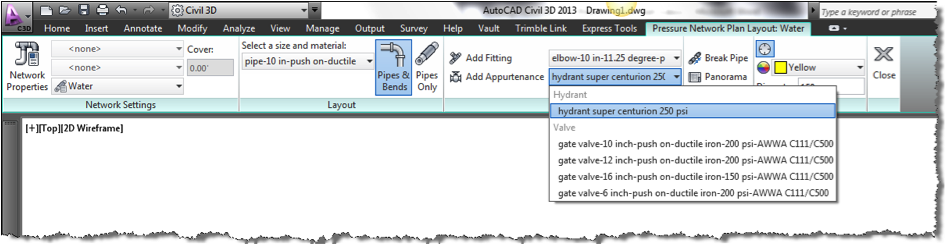
6. Finally, choose the hydrant/part you created by creating a new or editing an existing pressure network; under Plan Layout tab click on Add Appurtenances


You can find more information in the Part Publishing Wizard User Guide saved with the default Civil 3D install at the following location: C:\Program Files\Autodesk\AutoCAD Civil 3D 2013\Sample\Civil 3D API\Part Publishing Wizard\PartPublishingWizardUsersGuide.docx.
 

Lastly, please keep in mind that customization is generally unsupported by Autodesk and Ideate Technical Support so a lot of trial and error and testing may be involved in the Pressure Part creation process.


Gaurav Bagga

Ideate Infrastructure Solutions Application Specialist


Gaurav is a well rounded Application Engineer and Project Manager for Infrastructure Solutions at Ideate based out of San Francisco. He has over 15 years experience in construction industry and has been helping numerous small, medium and ENR 500 firms maximize their CAD investment for the last ten years. Gaurav is an Autodesk Certified Instructor and Autodesk Civil 3D Implementation Certified Expert. He has taught at several conferences, CAD Camps and Autodesk University. He has taught AutoCAD, Civil 3D, Land Desktop and Map 3D to thousands of students and helps Ideate develop the Infrastructure Services curriculum and courses. With his extensive CAD technology background he helps Bay Area engineering and surveying firms analyze and improve their design and drawing production process thereby improving productivity and the bottom line. Follow Gaurav on Twitter: @BeGeez

Get it. Know it. Use it.
Read More
Posted in AutoCAD, AutoCAD 2013, AutoCAD Civil 3D, AutoCAD Civil 3D 2013, Civil 3D, Ideate, Ideate Inc., matt miyamoto | No comments

Monday, 8 October 2012

Autodesk Certification Day – 10.12

Posted on 10:00 by Unknown
Autodesk certifications are a reliable validation of your skills and knowledge, and can lead to accelerated professional development, improved productivity, and enhanced credibility for you and your employer. 

Ideate is pleased to be participating in Autodesk Sponsored Certification Days for 2012. On the dates listed below, you have the opportunity to take an Associate, Professional or both Associate and Professional Certification Exam(s) for the discounted price of $25 ($100+ savings!). This is a great price to renew or get a new Autodesk certification (Autodesk Revit Architecture, AutoCAD or AutoCAD Civil 3D). 

The last 2012 certification day is: 
  • October 12th 
Ideate will be offering exams at our San Francisco, San Jose, Seattle and Portland offices during the dates above. 

Students can purchase their exams here. To take advantage of this promotion enter the codes below in the ‘shipping details’ section when checking out. 
  • San Francisco: AM0079 
  • San Jose: AM0078 
  • Seattle: AM3702 
  • Portland: AM3452 
For questions email education@ideateinc.com or call 888.662.7238 x1012
Read More
Posted in ATC, Authorized Training Center, AutoCAD, AutoCAD Civil 3D, Autodesk Authorized Certification Center, Autodesk Certification, Civil 3D, Ideate, Ideate Inc., Revit Architecture | No comments
Older Posts Home
Subscribe to: Posts (Atom)

Popular Posts

  • Civil 3D 2013: 2D and 3D Polyline Conversion
    While working on a grading I needed to change grades along a path that had been defined as a 2D polyline. Well, it is a fact that a 2D polyl...
  • Civil 3D Technology Preview – Corridor Solids for Civil 3D 2012
    How do you import a Civil 3D corridor into Revit or Navisworks? I was asked this question a couple of months ago while importing a Civil 3D ...
  • The Infamous FILEDIA System Variable
    Here at Ideate, one of the common issues we hear about while on tech support is that a customer is not able to use a dialog box to select fi...
  • Revit MEP Tip - Single Column Panel Schedules
    When Revit MEP introduced the concept of panel schedule templates that enable you to control the appearance of electrical panel schedules. B...
  • What's in a Multi-Category Schedule?
    Ever wondered what’s in a Autodesk Revit Multi-Category schedule? Here’s the skinny…while a regular Revit Schedule reports on a single cate...
  • Commitment to Change
    We all believe that we are good at 'change'. We are 'champions of change'. But is that really true? Why are people, in gener...
  • AutoCAD Civil 3D 2014: Hidden Command – Export to DGN
    At Ideate we are always digging and searching information to help improve your workflow. Have you ever needed to export your drawing to DGN ...
  • Insertion Point: Revit Families
    Question: How do you define/change the insertion point of a Revit Family? Answer: From the properties of the reference planes in the Revit ...
  • Grayed Out/Unavailable Parameters in Revit Families
    Working as the Ideate Support Tech the other day, I ran into a question where a user wanted to change a value of a parameter within a family...
  • Exploded Axonometric Views in Revit 2014: No Problem!
    Thank you for visiting Ideate’s blog to check out the new features added to Autodesk Revit 2014. My name is Shruti Harve and I work as a Sen...

Categories

  • .NET 4.5
  • .NWC file
  • #ADSK2012
  • #ADSK2013
  • #adsk2014
  • #AU2011
  • #AU2012
  • #AU2013
  • 2014
  • 2014 Migration
  • 360
  • 360 account
  • 360 online options
  • 3D
  • 3D Axon
  • 3d design
  • 3d Object
  • 3d Scanning
  • 3D View
  • 3ds Max
  • 3ds Max 2014
  • 3ds Max Design
  • ACI
  • adoption
  • ADSK2014
  • AEC
  • AEC Application Specialist
  • AECbytes
  • AIA
  • AIA CEU
  • AIA LU
  • AIM
  • Air Terminal Duct Enhancement
  • Airborne
  • Alternate Dimensions
  • Annotation Scale Unit Scale
  • Apple Boot Camp
  • Architectural Project Manager
  • ASHRAE
  • Assembly Code
  • Asset Browser
  • assign pay items
  • ATC
  • AU
  • AU 2012
  • Aurecon
  • Authorized Training Center
  • AutoCAD
  • AutoCAD 2012
  • AutoCAD 2013
  • AutoCAD 2014
  • AutoCAD Architecture
  • AutoCAD Civil 3D
  • AutoCAD Civil 3D 2012
  • AutoCAD Civil 3D 2013
  • AutoCAD Civil 3D 2014
  • AutoCAD for Mac
  • AutoCAD for Mac 2013
  • AutoCAD LT
  • AutoCAD Map 3D
  • AutoCAD Mechanical
  • AutoCAD MEP
  • AutoCAD MEP 2012
  • AutoCAD MEP 2013
  • AutoCAD MEP 2014
  • AutoCAD Plant 3D
  • AutoCAD WS
  • Autodesk
  • Autodesk 2014
  • Autodesk 360
  • Autodesk 360 account
  • Autodesk 360 Settings
  • Autodesk 3ds Max Design
  • Autodesk 3ds Max Design 2013
  • Autodesk Authorized Certification Center
  • autodesk authorized developer
  • Autodesk Authorized Training Center
  • Autodesk Autodesk Authorized Training Center
  • Autodesk Autodesk Revit MEP
  • Autodesk Certification
  • Autodesk Certified Instructor
  • Autodesk Civil Infrastructure Specialized
  • autodesk cloud
  • autodesk community
  • autodesk construction specialization
  • Autodesk Consulting Services Partner
  • autodesk corrupt file
  • Autodesk Design Review
  • Autodesk Design Suites
  • Autodesk Ecotect
  • autodesk exchange apps
  • Autodesk Fabrication Specialization
  • autodesk file crash
  • autodesk forum
  • Autodesk Gallery
  • Autodesk Green Building Studio
  • Autodesk Impression
  • autodesk infrastructure modeler
  • Autodesk Instructor Certification
  • Autodesk Labs
  • Autodesk License Manager
  • Autodesk licensing
  • Autodesk M&E
  • Autodesk Maya
  • Autodesk MEP
  • Autodesk MEP 2014
  • autodesk mep systems specialization
  • autodesk mosaic
  • Autodesk Navisworks
  • Autodesk Navisworks 2012
  • Autodesk Navisworks 2013
  • Autodesk Navisworks 2014
  • Autodesk Navisworks Manage
  • Autodesk Navisworks Simulate
  • Autodesk Partner
  • Autodesk Product Support Specialization
  • Autodesk Quantity Takeoff
  • Autodesk ReCap
  • Autodesk Reseller
  • Autodesk Revit
  • Autodesk Revit 2012
  • Autodesk Revit 2013
  • Autodesk Revit 2014
  • autodesk revit architecture
  • Autodesk Revit Architecture 2012
  • autodesk revit architecture 2013
  • Autodesk Revit Architecture 2014
  • Autodesk Revit MEP
  • Autodesk Revit MEP 2013
  • Autodesk Revit MEP 2014
  • Autodesk Revit Structure 2013
  • Autodesk Revit Structure 2014
  • autodesk roadway design
  • Autodesk Showcase
  • autodesk simulation specialization
  • Autodesk SketchBook Pro
  • Autodesk Software
  • Autodesk software installation
  • autodesk specialization
  • Autodesk Structural Engineering Specialization
  • Autodesk Subscription
  • Autodesk Technical Support
  • autodesk training
  • Autodesk University
  • Autodesk Vault
  • AutoLISP
  • Axis
  • Below Ribbon
  • Bentley
  • Best Practices
  • Beyond the Basics
  • bill johnson
  • BIM
  • BIM 360 Field
  • BIMLink
  • bimlink for revit
  • blame
  • Bob Palioca
  • Bradley Cooley
  • BUGIE
  • Building Design Suite
  • building information modeling
  • Bullit Center
  • business
  • Business Analysis
  • BVN Architecture
  • CAD
  • CAD Files in Revit
  • CAD Files. Eugene O'Day
  • CAD Imports
  • CAD Links
  • CADLearning
  • CADLearning Portal
  • Certified Instructor
  • change
  • Citrix
  • Civil
  • Civil 101
  • Civil 3D
  • Civil 3D 2012
  • Civil 3D 2014
  • Civil 3D Fundamentals
  • civil 3D.
  • clash detective
  • Clinton Maulder
  • Cloud
  • cloud 360
  • CloudOn
  • COBie
  • COBie Guide
  • collaborate
  • Collaboration
  • Command Line
  • Commandline
  • commitment
  • Common Materials
  • Competition
  • Conduit Size
  • consulting
  • continuing education
  • corporate culture
  • corridor solids
  • create pipe table
  • create structure table
  • CSV
  • customer satisfaction
  • Cyclone
  • Data
  • Data References
  • Data Shortcuts
  • data sources
  • David Haynes
  • Derek Wielkopolski
  • Diagrammatic 3D views
  • Differentiator
  • Digital Entertainment
  • Displaced Views
  • Displacement
  • disruptive
  • DOE Solar Decathlon
  • drawing audit
  • Dropbox
  • Duct Pipe Elbow Specific Angle
  • DWF
  • dwg
  • Eagle Point
  • Ecotect
  • Ecotect Analysis
  • Edit Materials
  • Edith Green Wendell Wyatt
  • eLearning
  • Electrical Fundamentals
  • elevation analysis
  • enhanced rebar shapes
  • Environmental Science Associates
  • ESA
  • Eugene O'Day
  • Excel
  • Excel to Revit
  • Exploded Axonometric
  • Exploded Isometric
  • Explorer
  • Export
  • export to DGN
  • export to excel
  • FARO
  • fatal error
  • File Repathing
  • File Support
  • File Type
  • FILEDIA
  • Fitting
  • FUD
  • Gary M. Davis
  • gaurav bagga
  • gis
  • Glynnis Patterson
  • Google Maps
  • Google Sheet
  • Green BIM Basics
  • Green Building Studio
  • Hague Justice Portal
  • highways
  • HMC Architects
  • hsw credits
  • Ideate
  • Ideate BIMLink
  • Ideate BIMLink for Revit 2013
  • Ideate BIMLink for Revit 2014
  • Ideate BIMLink for Revit 2014.1
  • Ideate BIMLink Survey
  • Ideate Consulting
  • Ideate Explorer
  • Ideate Explorer for Revit
  • Ideate Explorer for Revit 2013
  • Ideate Explorer for Revit 2014
  • Ideate Inc.
  • Ideate presents
  • IdeateBIMLink
  • IdeateInc
  • improvement
  • IMSCAD
  • Inc.
  • InfaWorks
  • Infrastructure
  • Infrastructure Design Suite
  • Infrastructure Modeler
  • Infrastructure Modeler 2014
  • InfraWorks
  • InfraWorks 360
  • Infraworks R2
  • Inroads
  • Interior Designers
  • Intersection Design Tool
  • intuition
  • Inventor
  • IPD
  • James Cowan
  • Jasmax
  • Javascript
  • Jeld-Wen Field
  • Jim Cowan
  • Jim Quanci
  • Jobsite Inspections
  • Kasian Architecture
  • kate ming
  • Laser Scan
  • Layer Key Style
  • Layer Standard
  • Lean
  • LEED
  • LEED AP
  • LEED Gold
  • Leica
  • license cascading
  • License Manager
  • LIDAR
  • lionakis
  • Lock
  • Lookup Table
  • LPAS Architecture and Design
  • M&E
  • Mac OS
  • Manage Paths
  • Map 3D
  • Marcel de Jong
  • Mark Schoennagel
  • Material Editor
  • Material Library
  • Materials
  • matt miyamoto
  • Maya
  • Maya LT
  • Measurement
  • Mechanical and Plumbing
  • mentor
  • mep
  • MEP 2014
  • MEP Ideate
  • MEP IDeate
  • Microsoft Windows 8
  • Mobile
  • Mobile Apps
  • Model
  • MotionBuilder
  • Move Objects away
  • Mudbox
  • Multi Rebar Annotation
  • Navisworks
  • Navisworks 2014
  • Navisworks Manage
  • negotiation
  • network
  • network deployments
  • Nicholas M Kramer
  • ObjectARX
  • Objects & Label Styles
  • OS X
  • PAE Consulting Engineers
  • Parallel
  • Parallels
  • PAT files
  • Patterns
  • Perpendicular
  • Phased Based
  • Phillippi Engineering
  • Photometric Lights
  • Pipe Network
  • Planning
  • PMI
  • PMP
  • point cloud
  • Point Clouds
  • POINTCLOUD
  • polyline
  • post-mortem
  • preparation
  • Presentations
  • Pressure Network
  • Pressure Pipe
  • Pressure Pipe Networks
  • Pressure Pipe References
  • Pressure Pipe Shortcuts
  • Product Key
  • project galileo
  • project management
  • Project Management Institute
  • Project Management Professional
  • Project Manager
  • Project Neon
  • project silverstar
  • Properties
  • Property Set Definition
  • Proposals
  • PSD Schedule
  • quantity takeoff
  • Randomization
  • RCP
  • RCS
  • Reality Capture
  • RealWorks
  • Rebar Constraints
  • Rebar documentation
  • Recap
  • Registry
  • Reinforcement Rebar Enhancements
  • Reinforcement Rounding
  • Rendering
  • requirements
  • Review
  • Revit
  • Revit 201
  • Revit 2013
  • Revit 2013.3
  • Revit 2014
  • Revit 2014 Model Performance Technical Note
  • Revit Architecture
  • Revit Architecture 2014
  • Revit Architecture Fundamentals
  • revit building information model
  • Revit elevation
  • Revit error
  • Revit Families
  • revit forum
  • Revit Ideate "Ideate Inc." Parameter Variance Vary Group
  • Revit MEP
  • revit mep 2012
  • Revit MEP 2014
  • Revit Model
  • revit multi-category
  • Revit Railings
  • revit schedule
  • revit schedules
  • Revit Server
  • Revit Server 2013
  • Revit Stairs
  • Revit Structure
  • Revit Structure 2012
  • Revit Structure 2014
  • Revit Technology Conference
  • Revit Tip
  • Revit to Excel
  • Revit tool
  • Revit Training
  • Revit User Group
  • Risk
  • roads
  • Robert Palioca
  • Ron Palma
  • RonPalmaAEC
  • Room Aware Families
  • Room Calculation Point
  • RTC
  • RTC Europe
  • RTCUSA
  • RVT
  • sash kazeminejad
  • Scan Data
  • Scanning
  • Scenarios
  • Scoping
  • scripts
  • Selling
  • Services
  • settings
  • SFRUG
  • shruti harve
  • Signage
  • Site tools
  • SketchBook Designer
  • SketchBook Designer 2013
  • Sketchbook Mobile
  • Sketchbook Mobile Express
  • SketchUp
  • solution
  • Spreadsheet
  • Stair Functionality
  • Stairs and Railings
  • Storm and Sanitary Analysis
  • strategy
  • Structural Analytical Model Improvements
  • Structural Rebar
  • Support
  • surface analysis
  • survey
  • Switch Geometry Order
  • SWOT
  • sync settings
  • syncing settings
  • Systems
  • tech support
  • technology
  • Temporary View Properties
  • thinking
  • Time of Flight
  • Tooltip
  • travel
  • Trillium Creek
  • Trimble
  • USGBC
  • Value
  • Vasari
  • Vault
  • VDC
  • View Properties Temporary
  • Virtualization
  • VM Ware
  • Wayfinding
  • William Johnson
  • Windows
  • Windows 8
  • Windows Server 2012
  • workflows
  • Workset
  • worksharing
  • Workspace
  • Xgen

Blog Archive

  • ▼  2013 (204)
    • ▼  November (15)
      • Negotiate - What you do every day
      • eLearning – Upcoming Classes
      • Classroom Training – Open Revit Classes
      • The Benefit of Failure
      • Ideate, Inc. Features Lionakis in Its First Ideate...
      • What's in a Multi-Category Schedule?
      • Commitment to Change
      • Workset Reporting with Ideate Explorer for Revit
      • Classroom Training – Open Revit Classes
      • eLearning – Upcoming Classes
      • When am I done? Why is the customer unhappy?
      • Classroom Training – Open Revit Classes
      • Ideate Presents: Autodesk Digital Entertainment SF...
      • eLearning – Upcoming Classes
      • Big Red Button vs. Elephant Eating
    • ►  October (19)
    • ►  September (14)
    • ►  August (18)
    • ►  July (23)
    • ►  June (14)
    • ►  May (25)
    • ►  April (31)
    • ►  March (15)
    • ►  February (11)
    • ►  January (19)
  • ►  2012 (204)
    • ►  December (13)
    • ►  November (14)
    • ►  October (19)
    • ►  September (18)
    • ►  August (19)
    • ►  July (12)
    • ►  June (17)
    • ►  May (23)
    • ►  April (27)
    • ►  March (19)
    • ►  February (10)
    • ►  January (13)
  • ►  2011 (92)
    • ►  December (10)
    • ►  November (9)
    • ►  October (16)
    • ►  September (13)
    • ►  August (19)
    • ►  July (14)
    • ►  June (11)
Powered by Blogger.

About Me

Unknown
View my complete profile